


Cup and Saucer Trail Manitoulin Island 2026: Epic Cliff Views, Inland Kayaking and Ontario’s Largest Freshwater Island Secrets


Sharing is SO MUCH APPRECIATED!

Last updated: April 17, 2026
Quick Answer
The Cup and Saucer Trail on Manitoulin Island is a free, moderate-difficulty hike featuring 70-meter cliffs along the Niagara Escarpment, with panoramic views of Lake Huron’s North Channel. The main red trail runs 5.7 km and takes about 2 hours, while an extended blue loop brings the total to 8 km [4][5]. Beyond the trail, Manitoulin — the world’s largest freshwater island — offers inland lake kayaking, sandy beaches, and deep Anishinaabe cultural experiences that most Ontario visitors never discover.
Key Takeaways
- Free to hike, year-round access. No registration, no entrance fee, and unstaffed parking at the trailhead [4].
- 70-meter cliffs stretching over 2 km make this the highest point on Manitoulin Island [2][5].
- Two route options: the 5.7 km red (Cup) trail or the 8 km extended blue loop [4].
- Moderate difficulty with rock scrambling and ladder sections — not stroller-friendly, but doable for reasonably fit hikers [3].
- Allow 2–3 hours for a comfortable pace with photo stops [3].
- Located 18 km west of Little Current, near M’Chigeeng, at Highway 540 and Bidwell Road [4][5].
- The 345-acre preserve sits within the Niagara Escarpment’s northern extension [1].
- Inland kayaking on Manitoulin’s interior lakes is a quieter alternative to Georgian Bay paddling.
- Best months: May through October for hiking; July and August for kayaking and swimming.
- Combine with culture: Manitoulin’s Anishinaabe communities offer powwows, art galleries, and guided heritage tours throughout summer 2026.

What Makes the Cup and Saucer Trail on Manitoulin Island Worth the Trip in 2026?
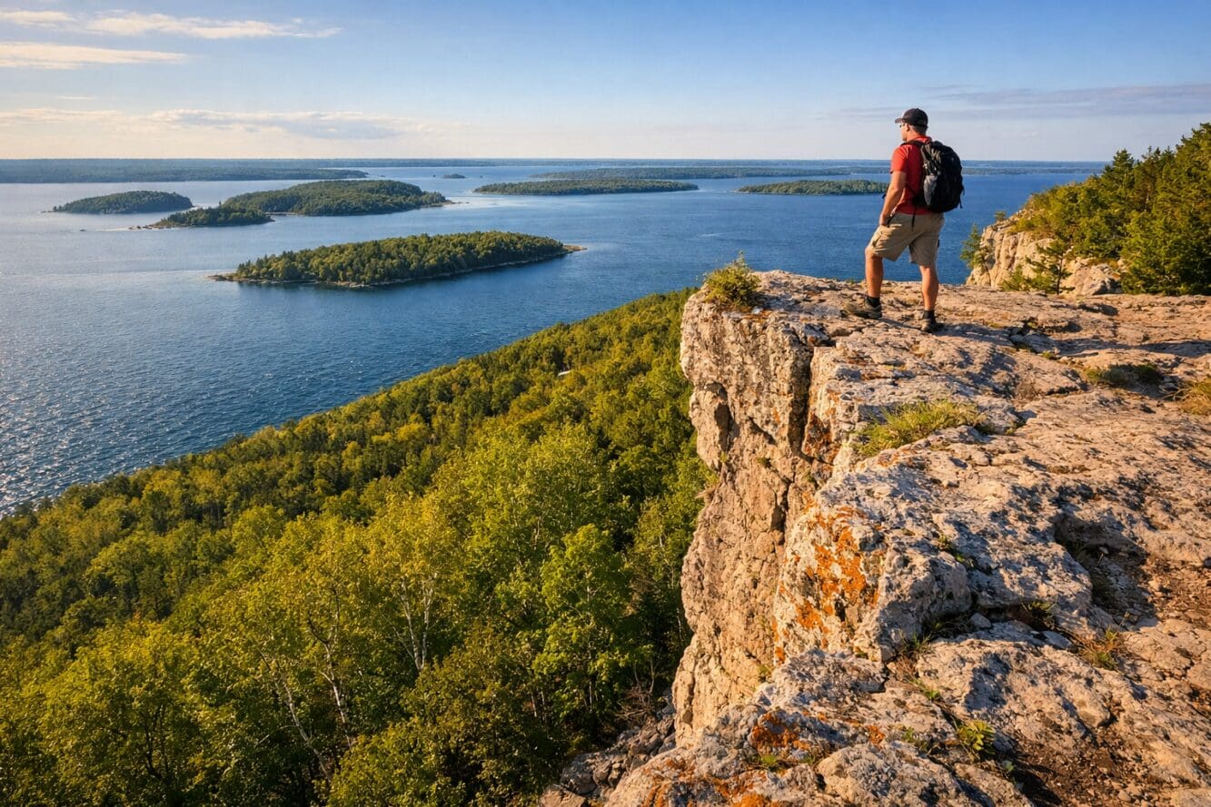
The Cup and Saucer Trail is the single most popular hike on Manitoulin Island, and for good reason: it delivers escarpment cliff views that rival anything in southern Ontario, without the crowds of Bruce Peninsula or Rattlesnake Point.
The trail sits within a 345-acre preserve managed by the Escarpment Biosphere Conservancy [1]. It follows the northern extension of the Niagara Escarpment — the same geological formation that creates Niagara Falls — but here, the rock forms dramatic 70-meter cliffs overlooking Lake Huron’s North Channel [5]. On a clear day, the view stretches across dozens of islands and the distant La Cloche Mountains.
What sets 2026 apart: Manitoulin has been steadily improving trail signage and access infrastructure. The trail remains completely free, which is increasingly rare for Ontario’s premier hiking destinations [4]. For anyone who values spending time in nature for rest and restoration, this is one of the best options in the province.
Choose this trail if: you want a genuine wilderness feel with real elevation and cliff exposure, but don’t want a full-day backcountry commitment.
Skip this trail if: you need wheelchair or stroller accessibility, or you’re uncomfortable with exposed heights and basic rock scrambling.
How Long Is the Cup and Saucer Trail, and Which Route Should You Pick?
The trail system offers 12 km of total hiking paths through hardwood forest [5]. Most visitors choose between two main routes:
| Route | Distance | Time | Difficulty | Best For |
|---|---|---|---|---|
| Red (Cup) Trail | 5.7 km | ~2 hours | Moderate | First-timers, families with older kids |
| Blue Trail Extension | Additional 5 km (8 km total loop) | ~3 hours | Moderate-hard | Experienced hikers wanting more solitude |
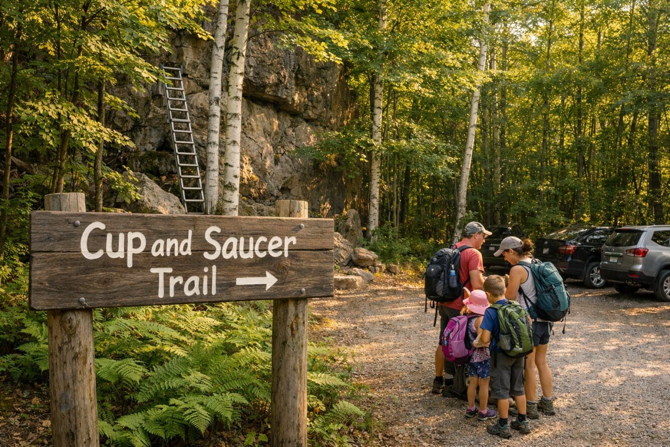
The red trail is the classic route. It climbs steadily through mixed hardwood forest before reaching the main cliff lookouts. Several sections require scrambling over rock and climbing short metal ladders bolted into the escarpment face [3][4].
The blue trail adds a half-loop extension that takes hikers deeper into the preserve, with additional viewpoints and fewer people. It’s worth the extra hour if you have the energy.
Common mistake: Many hikers underestimate the time needed. Even fit hikers should budget at least 2 hours for the red trail alone, and that’s moving at a steady pace without long photo stops [3]. Add 30–45 minutes if you want to actually enjoy the lookouts.
What’s the Difficulty Level, and How Should You Prepare?
The Cup and Saucer Trail is rated moderate, but “moderate” here means something specific: expect uneven rocky terrain, tree root obstacles, exposed cliff edges without guardrails, and short ladder climbs [3].
Essential gear checklist:
- Sturdy hiking boots or trail shoes (not running shoes — the rock is slippery when wet)
- At least 1 liter of water per person (no water sources on trail)
- Sunscreen — and dermatologists recommend never skipping it outdoors
- Bug spray (black flies are aggressive May through mid-June)
- Snacks or a packed lunch
- A charged phone with offline maps downloaded (cell service is unreliable)
Edge case: The trail is technically open year-round [4], but winter hiking here is a different beast. Ice on the cliff sections and ladders creates genuine danger. If you go between December and March, bring microspikes and trekking poles at minimum.
For families: Kids aged 8 and up who are comfortable with heights generally do fine on the red trail. Younger children or anyone with a fear of exposure should stick to the lower forest sections.
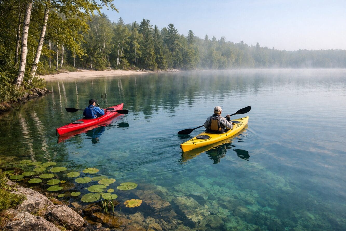
What About Inland Kayaking on Manitoulin Island?
Manitoulin Island contains over 100 inland lakes — some of which themselves contain islands, making this one of the most geographically unusual places in North America.
While the Cup and Saucer Trail handles the elevation and cliff drama, kayaking on Manitoulin’s interior lakes provides a completely different experience: calm, sheltered water surrounded by boreal forest, with far less boat traffic than Lake Huron or Georgian Bay.
Top inland kayaking spots near the Cup and Saucer Trail:
- Lake Manitou — the world’s largest lake on a freshwater island. Warm enough for swimming by mid-July, with sandy entry points and consistent calm conditions.
- Lake Mindemoya — smaller and more sheltered, excellent for beginners and families.
- Lake Kagawong — connects to Bridal Veil Falls, allowing a paddle-and-hike combination day.
Rental availability: Several outfitters in Little Current and Providence Bay rent kayaks and canoes by the hour or day. Booking ahead is smart for July and August weekends.
Decision rule: Choose inland lake kayaking if you want relaxed, flat-water paddling. Choose North Channel kayaking if you’re experienced and want open-water exposure with island-hopping routes.
This kind of trail and nature connection — blending hiking with water activities — is what makes Manitoulin a multi-day destination rather than a day trip.
What Are the Freshwater Island Secrets Most Visitors Miss?
Most people drive to Manitoulin, hike Cup and Saucer, and leave. That’s a mistake. The island rewards those who stay at least two or three days.
Cultural experiences:
- Ojibwe Cultural Foundation in M’Chigeeng (the same community near the trailhead) offers exhibits on Anishinaabe history, art, and language.
- Summer powwows run throughout July and August across several First Nations communities on the island. These are open to respectful visitors and are among the most authentic cultural events in Ontario.
- Immersion Tours — several Indigenous-led operations offer guided hikes, medicine walks, and storytelling sessions.
Hidden natural spots:
- Bridal Veil Falls in Kagawong — a short, easy walk to a beautiful waterfall that’s swimmable at the base.
- Providence Bay Beach — the longest sandy beach on Manitoulin, with shallow warm water that feels more Caribbean than Canadian Shield.
- Misery Bay Provincial Nature Reserve — an alvars ecosystem (rare globally) with unusual wildflowers and fossils.
Practical secret: The Chi-Cheemaun ferry from Tobermory to South Baymouth is scenic but books up fast in peak summer. Reserve ferry tickets at least two weeks ahead for July and August crossings. Alternatively, drive in via the Little Current swing bridge from Highway 6 — no reservation needed, but expect brief waits when the bridge opens for boat traffic.
For those interested in how nature-directed approaches benefit communities and ecosystems, Manitoulin’s conservation efforts around the escarpment and alvars are worth studying.
How Do You Get to the Cup and Saucer Trailhead?
The trailhead is located 18 km west of Little Current, at the junction of Highway 540 and Bidwell Road, near the community of M’Chigeeng [4][5].
Driving directions from major cities:
| Starting Point | Distance | Drive Time (approx.) |
|---|---|---|
| Toronto | 475 km via Hwy 400/69/6 | 5.5–6 hours |
| Ottawa | 530 km via Hwy 17 | 6 hours |
| Sudbury | 160 km via Hwy 6 | 2 hours |
| Tobermory (ferry) | Ferry + 65 km drive | 2.5 hours total |
Parking: Free, unstaffed gravel lot at the trailhead. It fills up on summer weekends by mid-morning, so arrive before 10 AM for guaranteed spots [4].
No public transit serves the trailhead. A car or bicycle is necessary.
When Is the Best Time to Visit in 2026?
Each season offers something different, but the sweet spots are clear:
- Late May to mid-June: Wildflowers peak, trails are less crowded, but black flies are intense.
- July and August: Best weather for combining hiking with kayaking and beach time. Busiest period.
- September to mid-October: Fall colour season. The hardwood forest along the escarpment turns spectacular, and the cliff views with autumn foliage are the island’s most photographed scenes.
- Winter: Open but challenging. Best for experienced winter hikers only.
Pro tip: Weekday visits in any season cut crowds dramatically. The trail can feel nearly private on a Tuesday morning in September.
For anyone planning a broader Ontario outdoor trip, events like those at community amphitheatres and outdoor venues pair well with a Manitoulin side trip.
What Are Common Mistakes Hikers Make on the Cup and Saucer Trail?
- Wearing the wrong footwear. Sandals and fashion sneakers appear on the trail regularly. The dolomite rock is unforgiving when wet.
- Not bringing enough water. There are zero water sources on the trail [4].
- Ignoring the cliff edges. No guardrails exist at the lookout points. Stay well back, especially with children or in windy conditions.
- Starting too late. In summer, afternoon thunderstorms roll in quickly. An early start avoids both heat and weather risk.
- Skipping the blue trail. The extended loop offers the best views with fewer people. If you have the time, take it.
- Assuming cell service works. Download offline maps before you leave your accommodation.
FAQ
Is the Cup and Saucer Trail free?
Yes. There is no entrance fee, no registration, and free parking at the trailhead [4].
Can dogs hike the Cup and Saucer Trail?
Dogs are allowed but must be kept on leash. The ladder and scrambling sections can be difficult for large dogs or dogs unfamiliar with rough terrain.
Is the trail suitable for children?
Children aged 8 and older who are comfortable with heights and uneven terrain generally handle the red trail well. It is not suitable for strollers or very young children [3].
How long does the Cup and Saucer Trail take?
The main red trail takes approximately 2 hours. The extended blue loop takes about 3 hours. Add extra time for photos and lunch at the lookouts [3][4].
Are there washrooms at the trailhead?
A basic portable toilet is sometimes available at the parking area, but don’t count on it. Use facilities in M’Chigeeng or Little Current before arriving.
Can you camp on the Cup and Saucer Trail?
No. Camping is not permitted within the 345-acre preserve [1]. Several campgrounds and accommodations are available nearby in M’Chigeeng and Little Current.
When is fall colour peak on Manitoulin Island?
Typically late September through the first two weeks of October, though this varies by year.
Is the Chi-Cheemaun ferry the only way to reach Manitoulin?
No. You can also drive across the Little Current swing bridge from Highway 6 on the north side of the island. The bridge is free and open year-round.
What’s the closest town to the trailhead for food and supplies?
M’Chigeeng is the nearest community, about 5 minutes by car. Little Current (18 km east) has more restaurant and grocery options [4][5].
Is the Cup and Saucer Trail part of the Bruce Trail?
No, but it sits on the same geological formation — the Niagara Escarpment. The Bruce Trail ends at Tobermory, across the water from Manitoulin’s south shore.
Conclusion
The Cup and Saucer Trail delivers one of Ontario’s best hiking experiences: dramatic 70-meter escarpment cliffs, Lake Huron panoramas, and genuine wilderness atmosphere, all for free. Combined with Manitoulin Island’s inland lake kayaking, sandy beaches, and rich Anishinaabe culture, this is a destination that justifies a multi-day visit in 2026.
Your next steps:
- Book accommodation early — Manitoulin fills up in July and August. Look at Little Current, M’Chigeeng, or Providence Bay.
- Reserve the Chi-Cheemaun ferry if coming from Tobermory (at least two weeks ahead for summer).
- Download offline maps of the trail before you go — cell service is unreliable.
- Plan at least two full days — one for the trail, one for kayaking and cultural exploration.
- Start your hike before 10 AM to secure parking and beat afternoon heat or storms.
Manitoulin Island remains one of Ontario’s most underrated outdoor destinations. The Cup and Saucer Trail is the headliner, but the island’s quieter secrets — the inland lakes, the powwows, the alvars — are what bring people back year after year. For those who enjoy exploring unique heritage and cultural experiences, Manitoulin delivers something no other Ontario destination quite matches.
References
[1] Cup And Saucer – https://escarpment.ca/see-our-preserves/manitoulin-north-channel/cup-and-saucer
[2] Cup And Saucer – http://www.ontariohighpoints.com/cup-and-saucer/
[3] Cup and Saucer Trail Reviews – https://www.tripadvisor.com/Attraction_Review-g528902-d626519-Reviews-Cup_and_Saucer_Trail-Manitoulin_Island_Northeastern_Ontario_Ontario.html
[4] Cup And Saucer Trail – https://2nerdsinatruck.com/cup-and-saucer-trail/
[5] Cup Saucer Trail – https://www.ontariotrails.on.ca/trail/cup-saucer-trail
[6] Big Hikes: Cup and Saucer’s Reward for the Adventurous – https://northernontario.travel/northeastern-ontario/big-hikes-cup-saucers-reward-adventurous
[7] Cup and Saucer on Trailforks – https://www.trailforks.com/region/cup-and-saucer-53072/
Content, illustrations, and third-party video appearing on GEORGIANBAYNEWS.COM may be generated or curated with AI assistance or reproduced pursuant to the fair dealing provisions of the Copyright Act, R.S.C. 1985, c. C-42. Attribution and hyperlinks to original sources are provided in acknowledgment of applicable intellectual property rights. Such referencing is intended to direct traffic to and support the original rights holders’ platforms.
Sharing is SO MUCH APPRECIATED!


